Search
Geotemporal Search - Gaia Map
Learn how Gaia's geotemporal search maps billions of species observations by time and location — and why it works differently from Google Maps for wildlife exploration.
Unlike conventional map services that display fixed points of interest — restaurants, train stations, landmarks — gaia.eco works with living, dynamic data: billions of recorded species observations tied to specific dates and locations.
This fundamental difference shapes every aspect of how gaia.eco operates, from its empty starting map to its date-dependent search results.
How Gaia Differs from Traditional Map Services
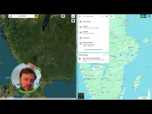
Traditional map services like Google Maps index immovable, man-made objects. A pizzeria stays at the same address year-round. A train station does not migrate with the seasons. These services can pre-load and display all nearby results the moment a user opens the app.
Gaia cannot do this — and by design, it does not try. The platform holds billions of species observations and millions of ecological relationships. Displaying all of this data simultaneously would render the map unreadable. Instead, Gaia opens with a blank map and relies on the user to define what they want to see, where, and when.
This is not a limitation. It is a deliberate interface decision that prevents information overload and gives users precise control over the data they retrieve.
What "Geotemporal Search" Means
Gaia describes its core functionality as a geotemporal search. Every query operates across two dimensions simultaneously: geography (where) and time (when). Both are required because biodiversity data is inherently seasonal and location-dependent.
A species that is abundant in one region during summer may be completely absent from that same region in winter. Searching without a date range would produce misleading or irrelevant results. By requiring temporal input, Gaia ensures that the data returned reflects actual ecological conditions.
Use Cases
Verifying Local Wildlife Activity
A user searching for squirrels in northern Germany during a recent quarter will find dense clusters of sightings, particularly around urban areas like Berlin. This confirms active populations and gives a snapshot of current biodiversity in that region. Researchers, educators, and citizen scientists can use this to validate field observations or plan surveys.
Understanding Seasonal Species Patterns
Searching for bumblebees in northern Sweden in late March — when the region is still snow-covered — returns no results. This is expected: bumblebees are inactive under those conditions. Shifting the same search to southern Sweden or Copenhagen reveals active species records, accurately reflecting the seasonal gradient of insect activity across Scandinavia.
This behaviour makes Gaia a practical tool for studying phenology — the timing of biological events — and for planning fieldwork around species availability.
Avoiding Empty Results with Ecological Context
A common initial frustration with Gaia is receiving no search results. In most cases, this happens because the selected date range falls outside the species' active period in that location. Understanding this pattern turns an apparent gap into useful ecological information: the absence of data is itself a data point about species behaviour and seasonal range.
Exploring Biodiversity for Travel or Education
Nature enthusiasts planning travel can use Gaia to check which species are observable at a destination during their travel dates. Educators can use it to demonstrate real-world ecological concepts — seasonality, migration, habitat range — with live data rather than static textbook maps.
Key Facts
Gaia's dataset includes billions of species observations and millions of ecological relationships.
The platform requires both a location and a date range for every search.
The map starts empty by design to prevent data overload.
Search results reflect real seasonal and geographic species patterns.
An empty result set typically indicates the species is inactive in that region during the selected time frame.
Gaia covers a wide range of taxa, including mammals, insects, plants, and other documented organisms.
How to Get Meaningful Results
Effective use of Gaia depends on approaching searches with basic ecological awareness. Consider the following when constructing a query:
Season matters. Search for species during their known active periods. Spring and summer searches tend to return more insect and plant observations in temperate regions.
Location precision helps. Narrowing the geographic scope produces more relevant clusters of observations rather than scattered, hard-to-interpret data points.
Date ranges should be intentional. A broader range captures more data; a narrower range gives a sharper temporal snapshot. Choose based on whether you need a trend overview or a specific-moment check.
Absence is informative. No results does not mean Gaia has failed. It may mean the species is dormant, has migrated, or has not been recorded in that area during the selected period.
Summary
Gaia operates on a fundamentally different principle from traditional map services. Where Google Maps indexes the permanent and static, Gaia indexes the living and temporal. Its geotemporal search model reflects the reality of biodiversity — species move, hibernate, migrate, bloom, and disappear with the seasons. By placing search control in the user's hands and requiring temporal context, Gaia delivers ecologically valid results without overwhelming its users. The platform is best suited for anyone who approaches nature data with curiosity and a willingness to factor in the rhythms of the natural world.
Forage for Biodiversity Data
Open map.gaia.eco.
Join our Community Forum
Any other questions? Get in touch