Analyse
GPS Coordinate Uncertainty and Basic Metadata
Learn why biodiversity datasets contain intentional GPS coordinate uncertainty to protect endangered species from poaching, how it affects spatial analyses, and best practices for attributing data creators and aggregators.
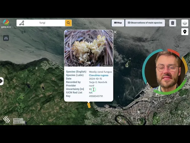
Observations contain GPS coordinates. Sometimes, there can be deliberate positional offset. Data providers introduce this uncertainty as a protective measure against the poaching of endangered or vulnerable species. Researchers and data consumers who work with biodiversity occurrence records must account for this practice when interpreting spatial data and drawing scientific or conservation conclusions.
Proper attribution of data creators and hosting databases is a parallel requirement. Together, these two concerns — spatial data reliability and source crediting — form the foundation of responsible biodiversity data use.
Intentional Coordinate Uncertainty
What It Is
GPS coordinate uncertainty refers to a deliberate reduction in the spatial precision of species occurrence records. Rather than publishing exact locality data, data providers obscure coordinates by rounding values, applying random offsets.
Why It Exists
Exact location data for threatened species creates a direct poaching risk. Publicly accessible coordinates can enable malicious actors to locate and harvest rare organisms. Intentional data disturbance mitigates this risk by making it impractical to derive precise field locations from published records.
The practice reflects an inherent tension in biodiversity informatics: the need for open, transparent data conflicts with the obligation to protect the species that data describes.
How It Affects Data Use
Coordinate uncertainty has several downstream consequences for data consumers.
Spatial analyses that depend on fine-grained locality data (e.g., habitat modeling, range mapping) may produce less precise results.
Aggregated datasets drawn from multiple providers may contain mixed levels of precision, requiring users to filter or weight records by their stated uncertainty values.
Reproducibility of location-based findings depends on whether the original precision is recoverable or permanently obscured.
Most biodiversity data standards, including Darwin Core, include fields for documenting coordinate uncertainty (e.g., coordinateUncertaintyInMeters). Users should consult these fields before incorporating records into analyses.
Data Attribution
Requirements
Biodiversity data originates from individual collectors, research institutions, citizen science platforms, and curated databases. Each of these contributors is entitled to proper acknowledgement when their data is reused.
Attribution typically involves crediting both the original data creator (the individual or team that collected the observation or specimen record) and the data aggregator or platform that hosts and distributes the data (e.g., GBIF, iNaturalist, or a national biodiversity portal).
Best Practices
Data consumers should follow the license guidelines published by each data point. For profit users should pay attention to CC-BY-NC licesnsing as these data points are not to be used in a commercial setting. Roughly 18% of data points are not for commercial use.
Recognizing data provenance supports a culture of responsible sharing within the biodiversity research community and incentivizes continued data publication by collectors and institutions.
Frequently Asked Questions
Why are GPS coordinates deliberately altered in biodiversity records? To prevent poachers and other malicious actors from using published data to locate endangered species in the field.
Does coordinate uncertainty reduce the scientific value of biodiversity data? It reduces spatial precision, which can affect certain analyses. However, understanding the purpose and extent of the uncertainty allows users to interpret records appropriately and select methods that accommodate imprecise coordinates.
Who should be credited when reusing biodiversity data? Both the original data creators (collectors, observers, or institutions) and the databases or platforms that aggregate and serve the data. Follow the given license of each data point.
Can coordinate uncertainty be quantified? Yes. Most standardized biodiversity data formats include metadata fields that document the degree of spatial uncertainty in meters.
Summary
Intentional GPS coordinate uncertainty is a standard protective practice in biodiversity data management. It balances the goals of open data access and species conservation by preventing the misuse of precise locality information. Data consumers should review uncertainty metadata before conducting spatial analyses and should consistently credit the individuals and platforms responsible for collecting and distributing biodiversity records.
Forage for Biodiversity Data
Open map.gaia.eco.
Join our Community Forum
Any other questions? Get in touch